Vitals
- Locale: Charlevoix, Quebec
- What It's Like: A bedrock paradise of ledges, rapids and waterfalls.
- Class: IV-IV+ (V) pool-drop
- Scouting/Portaging: Easy to moderate.
- Level: Gauge found here.
- Time: 3-4 hours for a first run.
- When To Go: Spring, summer and fall. Often has runnable flows from rain after the snow has melted.
- Info From: Several visits between 20-40 cms.
- Other Beta: None.
- Map: Click here for a map of the river zone.


Description
This page was last updated in November 2008 and it is not regularly maintained. Information may be inaccurate.
The Malbaie is a classic, well-known river run found in the Charlevoix region east of Quebec City. From start to finish it offers up pretty much only bedrock ledges, drops and clean falls, all easily scoutable and all good to go. The highlight of the run is a perfectly clean, picturesque 30+ foot waterfall that almost seems out of place in the east. The majority of the whitewater is fun class IV, with the exception of the falls. It is one of the best moderate difficulty runs in Quebec. The only downside is that the river is far away from everything!
This beta is based on flows between 20-40 cms. The run, including the big falls, is relatively low stress at 20 cms. It could be done lower but it wouldn't be worth a long drive. At 40 cms the run comes into its own as a classic with amazing rapids connecting exciting big ledges and falls. It is worth a long drive at this level. A report from a trip at 60 cms said the big falls was marginal, and many of the rapids were either unrunnable or incredibly intimidating because of the presence of many big holes.
Getting to the Malbaie takes a long time, unless you live in Quebec City. The road to the take out is rough and may require 4x4, or at least some clearance (as of 2008). To reach the river, drive east of Quebec City on the 138 until you reach a community called Baie St. Paul, where you'll turn north on the 381. Drive on the 381 for approximately 50-60 km (enjoy the scenery), whereupon you'll first cross the Petit Malbaie and then the Malbaie (both are marked with signs). After you cross the Malbaie, there will be a right turn on to a dirt road about 5 km past the bridge.
Follow the dirt road downstream along the river. After about 6-8 km the road will cross to river right - there will be a cabin on the other side of the bridge. It is possible to start at this bridge, but there will be a lengthy flat water paddle to begin with. To continue to the other put in, drive for about 7-8 km and keep left at both forks. The third intersection you reach will be a 4-way intersection. Going straight brings you to the takeout and turning left is the path to the put-in. Here's a satellite map showing where you drive in from the 381 (point A), the early put-in at the bridge (point B) and the takeout (point C).
The old road to the put in is overgrown and takes about 1/2 hour of walking to reach the river. The road from the 4-way intersection to the takeout is rough. The take out bridge is 6 km from the intersection. There is a section of whitewater below the takeout bridge, but we don't have any beta on what it's like, how to get there or what the flows should be. Apparently the roads are bad.
Once at the river, the whitewater starts right away with some fun class II-III warm up rapids. The first distinct bedrock ledge marks the start of the good part of the river. Expect a lot of grade III-IV bedrock type rapids, some of which will push the harder end of class IV at higher flows. The big waterfall is an unmistakable horizon line that can be scouted/portaged on the left. The line off the waterfall varies with water level, and it is quite intimidating at high water. More of what you found above the falls continues down to the take out bridge. Climb out on river left, below the bridge. Enjoy this part of Quebec, it's pretty awesome there.
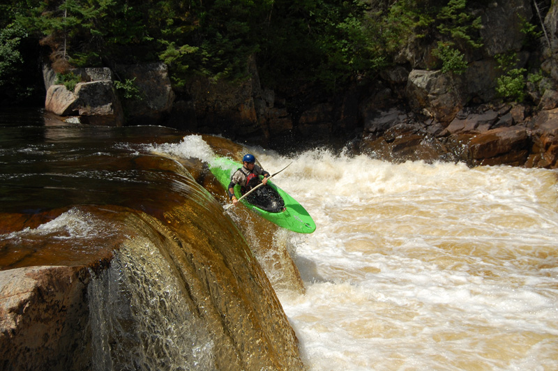 An easy ledge at the start of the run.
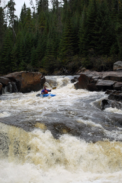 A typical Malbaie rapid at medium-low flow.
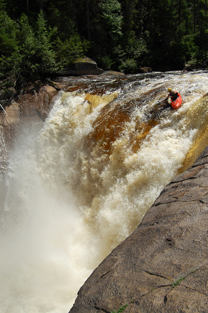 Rolling in to the big waterfall, from the right eddy.
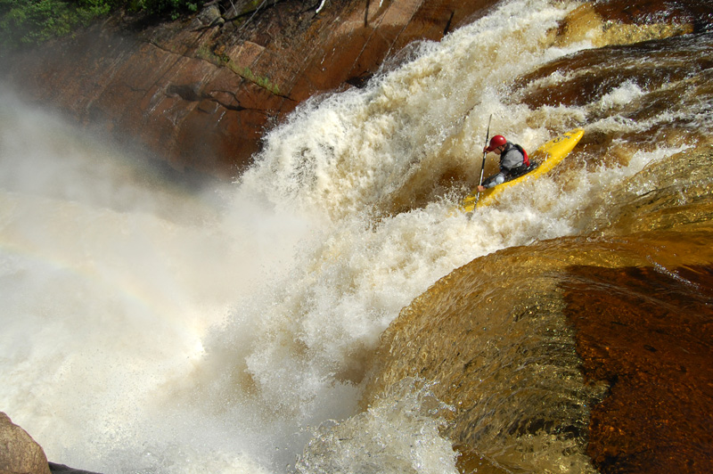 Looking down the gut of the big falls.
Updated Nov 3, 2008

